
Ythan Estuary and Forvie Sands Saltmarsh
Key Findings
The saltmarsh at the Ythan mouth is the largest area of saltmarsh along the East Grampian coastline (SNNR, 2024). Fig. 1 shows a detailed outline of the Ythan Estuary saltmarsh sites. The wider area – Sands of Forvie and the Ythan Estuary – is an internationally important site, home to a diverse array of habitats, from sand dunes to rocky shores with both fresh- and saltwaters (SNNR, 2024). A diverse habitat brings a diverse array of wildlife, with the site supporting species both common and uncommon to the British Isles. For example, the site supports 30% of Scotland’s rare little tern population, 9% of the UK’s Pink-footed geese population, and two rare species of liverwort only found in dune slacks (SNNR, 2024). The sand dunes of the site are part of the 5th largest dune system in the UK, and are remarkably unaltered (Scottish Natural Heritage, 2011) – see the ‘Saltmarsh Quality’ sheet.
Not only is the site ecologically important, but also archaeologically. Due to the dynamic landscape and constant ‘shifting sands’, the site has preserved many artefacts and structures (Noble et al, 2016). Mesolithic/Neolithic artefacts and a large Bronze/Iron age settlement are just a few of the important discoveries made at the site (Noble et al, 2016).
To maintain this unique habitat, the site is protected by multiple nature conservation designations. Figures 2, 3 and 4 breakdown the protected designations of the Ythan Estuary and Forvie Sands, with the saltmarsh itself shown in green.
The Ythan Estuary saltmarsh is designated:
- Forvie NNR (Blue outline) (NatureScot, 1988)
- Sands of Forvie and Ythan Estuary SSSI (Blue outline) (NatureScot, 1984)
- Ythan Estuary, Sands of Forvie and Meikle Lock SPA (Red outline) (NatureScot, 2020)
Additionally, the saltmarsh is within meters of the Sands of Forvie SAC (Purple outline) (NatureScot, 2005)
Detailed maps of these designations can be found at: https://sitelink.nature.scot/home?q=forvie
Please see the ‘Nature Conservation Designations’ sheet for details on these designations.
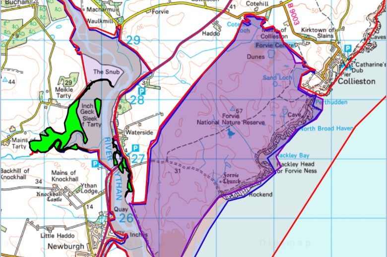
Fig. 1: Ythan Saltmarsh (Scottish Government, 2012)
Notes
Linked Information Sheets
Seafood Landings by Value into the North East of Scotland - Employment in the fishing industry offshore- Employment in the fishing industry onshore- Markets for Seafood - Fraserburgh Harbour, Peterhead Harbour - Aberdeen Harbour - Small Harbours north of Aberdeen - Small Harbours South of Aberdeen – Status of key commercial species – Numbers of fishing vessels – Training - Employment - Mackerel line catch value
Key sources of Information
NatureScot (1984) Sands of Forvie and Ythan Estuary SSSI
NatureScot (2005) Sands of Forvie SAC
NatureScot (2020) Ythan Estuary, Sands of Forvie and Meikle Loch SPA
SNNR (2024)The Story of Forvie National Nature Reserve 2nd Edition
Scottish Government (2012) Saltmarsh Survey (Habitat Map of Scotland) (NatureScot WMS)
Reviewed on/by
Status
First Draft (this is for demonstration only at this time and has not been reviewed)
To report errors, highlight new data, or discuss alternative interpretations, please complete the form below and we will aim to respond to you within 28 days
Contact us
Telephone: 07971149117
E-mail: ian.hay@stateofthecoast.scot

We need your consent to load the translations
We use a third-party service to translate the website content that may collect data about your activity. Please review the details in the privacy policy and accept the service to view the translations.