
Flooding Trends
Key Findings
One of the main manifestations of climate change in Scotland is flooding. Increasing extreme rainfall and storm events mean more homes than ever are at risk, with the total number of buildings vulnerable to floods projected to reach 400,000 by 2080 – an increase of 110,000 (SEPA, 2021). By 2100, Scotland can expect an increase in most types of flood with peak river flow projected to rise by 60%, peak rainfall by 50%, and sea level by between 80 and 190 cm (Scottish Government, 2024).
Why are floods increasing?
Warming global temperatures are causing what NASA describes as an “enhancement of the water cycle”, increasing the water evaporated from oceans and other water sources (Rayne, 2025). Scotland’s position within global circulation systems means this water cycle enhancement will bring increased extreme storms and rainfall.
In addition to an intensified water cycle, changes to the Polar Jet Stream are likely to contribute. The Polar Jet Stream is a jet of fast flowing high-altitude winds caused by pressure gradients in the atmosphere. Warming artic temperatures are causing the jet to slow and become more variable in its track (Arctic Council, 2024). As shown in figure 1, this phenomenon is carrying cold arctic air further south and warmer equatorial air further north. This means Scotland will experience periods of intense stormy conditions when flood risk is greater, as well as periods of unusual warmth and dryness when droughts may take place. To learn more about Scotland’s drought risk, please see our ‘Drought’ page.
Where is at risk?
Figure 2 shows Scotland’s Potentially Vulnerable Areas (PVAs) to flooding for both 2022-2028, and 2028 – 2034 (SEPA, 2022). Across the map, settlements are most often within these PVAs due to their impermeable urban infrastructure poorly designed for coping with high volumes of water. While the PVAs reduce in size for the 2028-2034 period, this is to do with a change in process for their classification rather than a real reduction in flood risk.
Figure 3 displays the predicted increase in people at risk of flooding across the UK under various climate warming scenarios. Aberdeenshire is consistently projected to experience the largest growth in this metric within Scotland, rising by 7,500 – 15,000 should warming reach 4°C. In Scotland only West Lothian and Glasgow City are likely to experience a similar growth in risk.
To examine the Aberdeenshire area more closely, SEPA and OS Maps (2024) host an interactive map of high-resolution flood risk data across Scotland. Some notable results are discussed below:
- Within Aberdeen city, a 10% annual river flood risk is identified for the city centre, areas of Midstocket along the North Burn of Rubislaw, as well as parts of Seafield, Woodend, Stoneywood and Dyce. Surface water flood risk is widespread across the city, while coastal flooding is mostly confined to the lengths of the beach esplanade.
- Along the East Grampian coast, other areas at risk of residential flooding include Portlethen, Stonehaven (majorly), Inverbervie, Johnshaven, Montrose, Balmedie, Newburgh, Cruden Bay, Peterhead, St Combs, Inverallochy, Fraserburgh, and the industrial areas north of both Boddam and St Fergus. In other words, most towns and villages along the East Grampian coast are currently or will soon be at risk of flooding.
To learn about examples of major floods Scotland has experienced, or the work underway to mitigate this increasing risk, please see the pages ‘Flooding Events’ and ‘Flood Mitigation Work’.
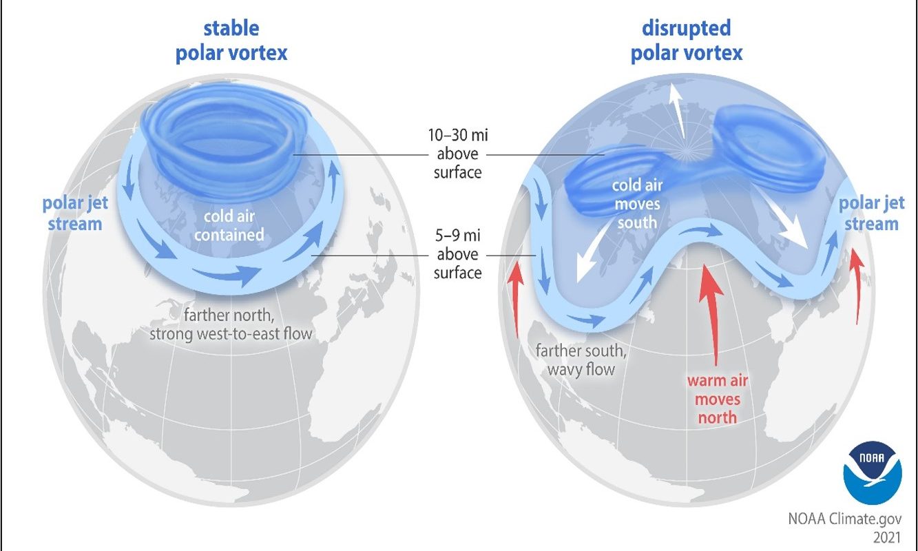
Fig. 1: Changes to the Jet Stream due to Climate Change: The stream is set to become much more variable and unpredictable, bringing changeable climate conditions to a wider range of latitudes. Diagram from NOAA (2019).
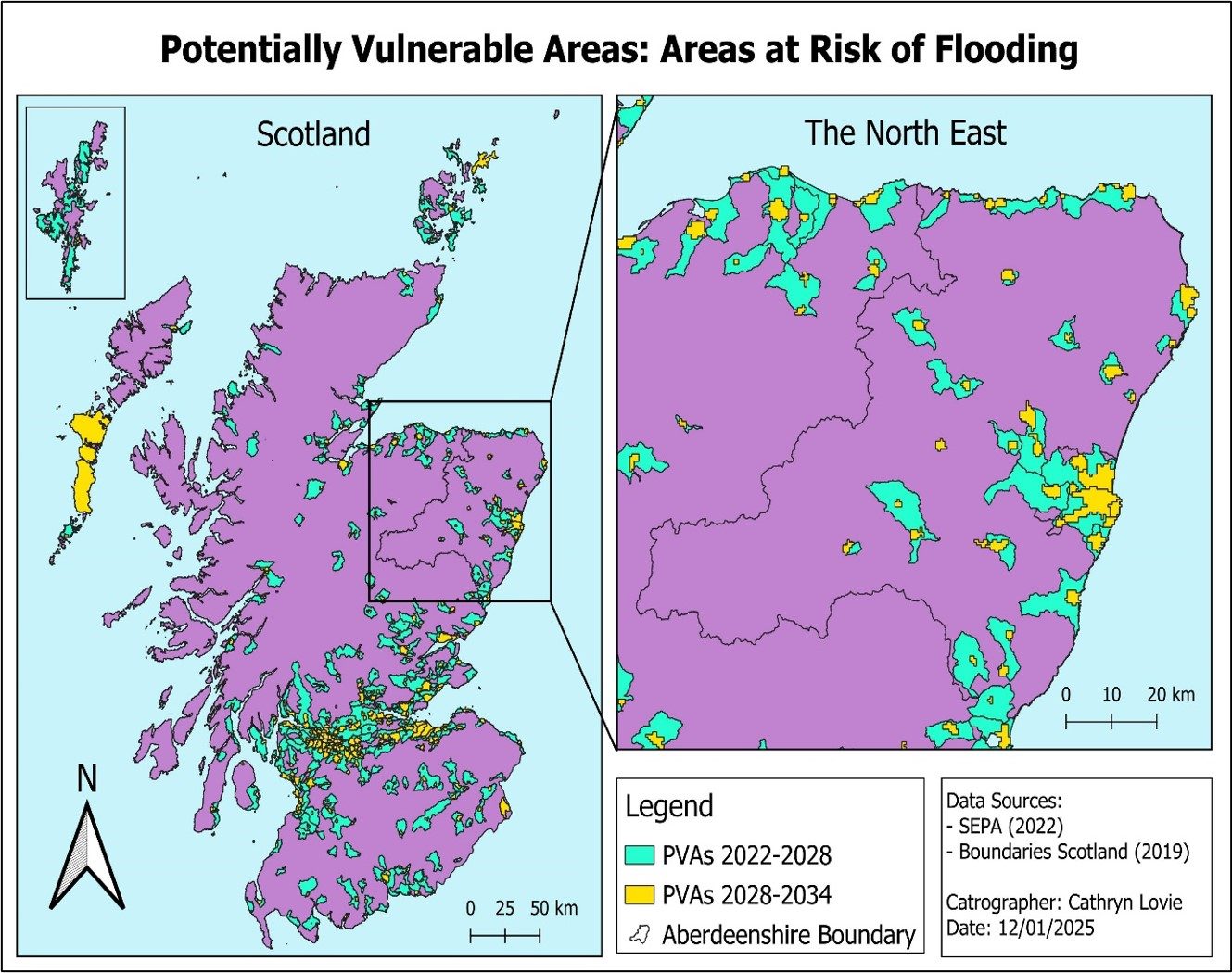
Fig. 2: Areas identified as potentially vulnerable to flooding in Scotland and the North East. This includes areas at immediate risk, and those which will be at risk in the future. From SEPA (2022) and Boundaries Scotland (2019)
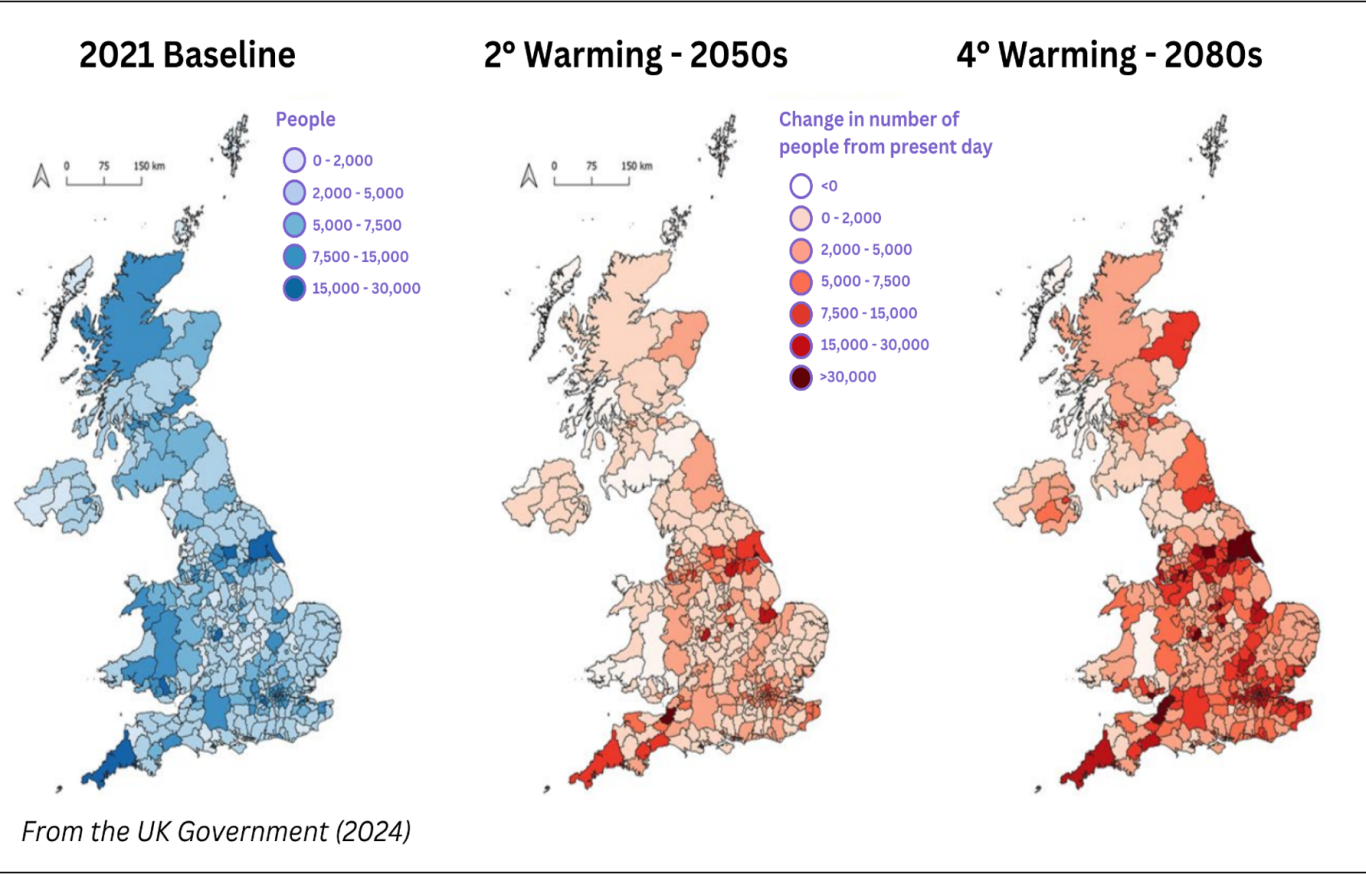
Fig. 3: Projected change in people at risk of flooding across the UK, based on two climate outcomes. From UK Government (2024)
Notes
None
Linked Information Sheets
Key sources of Information
Arctic Council (2024) Shifting Winds: How a Wavier Polar Jet Stream Causes Extreme Weather Events
Boundaries Scotland (2019) Local Authority Areas – Scotland
NOAA (2019) The science behind the polar vortex: You might want to put on a sweater
Rayne (2025) Water & Energy Cycle
Scottish Government (2024) National Flood Resilience Strategy
SEPA (2021) Flood Risk Management Plan: North East Local Plan District
SEPA (2022) Potentially Vulnerable Areas Flood Maps
SEPA and OS Maps (2024) SEPA Flood Maps
UK Government (2024) Climate change, flooding, coastal change and public health
Reviewed on/by
Status
First Draft
To report errors, highlight new data, or discuss alternative interpretations, please complete the form below and we will aim to respond to you within 28 days
Contact us
Telephone: 07971149117
E-mail: ian.hay@stateofthecoast.scot

We need your consent to load the translations
We use a third-party service to translate the website content that may collect data about your activity. Please review the details in the privacy policy and accept the service to view the translations.